D&d Fantasy Map Art - Personal Project [WIP]
This is a personal project of mine made for my D&d game with my family. It is still a work in progress. I wanted to make something that not only fits in my interest of Level design, World Building, Environment art, etc.., but that also had a practical use for myself. I also wanted to expand my horizons and my knowledge beyond 3d art and design. World Map Art & Design happens to be what caught my personal interest.
-
Now as for details on the project, I purchased and used the software called "Wonderdraft" to create this. Other than looking up occasional tutorials, references and advice, and using knowledge from my experiences with video game maps, I basically self-taught myself how to make maps and how to use the software.
-
All of the assets including things like images, stamps, and fonts are from the software, or downloaded online. I do not plan to sell this anywhere.
-
Other than that, everything is done by me. I designed the continent, the environments, the borders and places. Using the software, I brushed the trees, rivers, lakes, mountains, roads, borders, patterns, labels etc. I placed the assets that denote settlements, sea creatures etc. I placed, and altered the text and configured color balances, color complements, color contrasts, etc. The names of locations and places either came directly from my head, or from inspiration from words in other languages, cultural references, random generators, or other media.
-
I understand it may be a little hard to read as is, but that is for a couple reasons. The first is that Artstation only allows images to be 10MB or less, so the quality was reduced compared to my original file. The second is I designed it to either be printed out at the size of a poster or to be zoomed in and out like in an open world game. So a small, still image isn't the optimal viewing method intended. But feel free to full sceen the image and zoom in a bit if you want to see a bit closer.
-
Now, as you will notice, the northern section of the continent, The Nocstol Federation, is the most complete. The simple reason for this is just that this is where the D&d game with my family takes place, so that is where I started first. I am almost done with it, and afterwards I will move on to the Southwest, Vaeruda Empire, and lastly to the Southeast, Drauggoran Dominion.
-
Something else I wanted to mention is that these are 2 versions of the same map. The colored one is the Biome map that has the names of the different biomes and environments. The parchment styled one is the settlement map for Nocstol that has the borders for the breakup of governmental territories. I will be making one for each of the other two major countries as well as Eorna.
-
Anyway, I would gladly appreciate any feedback from anyone who wishes to give it.
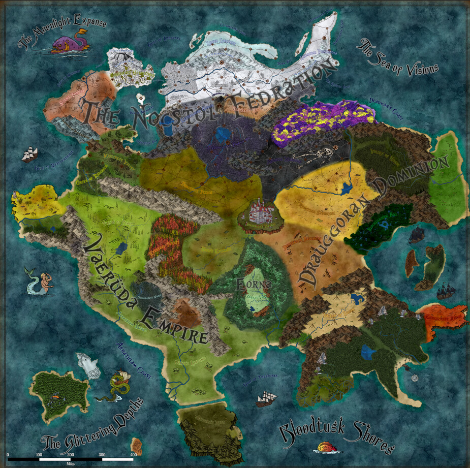
Continent, Full Color View

The Nocstol Federation

Northern Vaeruda Empire

Southern Vaeruda Empire

Northern Drauggoran Dominion

Southern Drauggoran Dominion

Eorna

The Empty Throne | Sovereign's Plateau

The Nocstol Federation Full View Map

Oriod, North Nocstol

Taurgaan, Northeast Nocstol

Aquadia, West Nocstol

Caprica, Central Nocstol

Leonis, South Nocstol

Cygorn, Southeast Nocstol